
| |||
|
|
Top Ten Historic Sites in Stony Valley & Surrounds 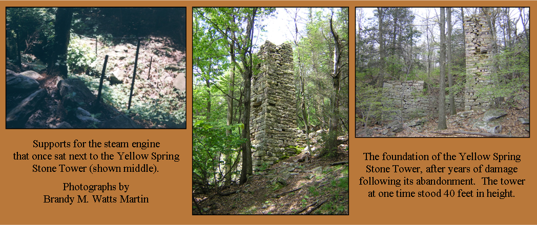 The tower stands proudly atop the mountain amongst the trees and underbrush, at the end of the Stone Tower Trail (not advisable for young children). The traveler receives its first glimpse of history from the back of the tower where rebar still protrudes from its side foundation. The tower itself stood approximately 35 to 40 feet in the air in the 1970s, and 10 feet at the base when Hikin’ Henry Knauber decided to scale its rocky side (then cut down the tree he used to do it so not to give the Boy Scouts any bad ideas). His discovery led to the many ideas the “Mystery Tower” could have been. To this day the exact use is unknown. Yet some of the ideas include an observation platform and ventilation for the neighboring mine shaft.
As of 2007, the explanation has changed again. My own explanation is that the tower was used as ventilation for a steam engine, used to run an incline plane, which carried coal down the mountainside to the coal breaker and train cars. Piers can still be found going down the mountainside from the original incline plane, which sat beneath the tower. The incline plane was built in 1851. However, by the time the incline plane had finally finished its life, a 276 foot deep mine shaft sat between the stone tower and incline. The mine headwork can still be seen today.
Maurice J. Forrester Jr. once wrote in a 1974 Sierra Club article: “It is, however, a magnificent example of the stonemason’s art, evoking unvarying admiration in the occasional hiker who pass that way. But slowly and relentlessly the passing seasons are taking their toll. Each year sees one or two more stones dislodged from their places and fallen to the ground. Inevitably, the day will come when the tower is nothing more than a jumbled pile of stones on top of the mountain.” Fortunately, that day has yet to come.
DIRECTIONS: From Route 225/325 Junction, continue east on Route 325, 16.8 miles until you reach a pulloff on your righthand side. The pulloff is marked with red blazes and blue A's on the trees. Park and followed the red-blazed Stone Tower Trail. You will cross Clark's Creek on a log and gradually climb the mountain, before turning steeply to your right up the mountainside. The whole hike TO the stone tower is approximately 2.5 miles.
Use State Game Lands #211 Map 2 of 3
StonyValley.com was created and is maintained by Schuylkill & Susquehanna Railroad Historian, Brandy M. Watts Martin. Copyright 2013. | ||